Street maps for Europe on Google Maps

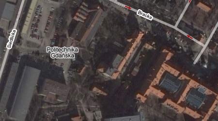
Google Maps has recently enabled both map and hybrid view for most of the Europe countries. This means that now they show names of the cities, streets and important institutions. And that, my friends, is great news!

Below, for example, is my alter matter. It’s not as colorful as it should be only because this aerial photo was taken during winter time (this past winter, I presume). It’s named properly in Polish (Politechnika Gdańska) and all the streets are there too:

Politechnika Gdańska on Google Maps

(via Digg)

Poland on Google Maps

Google Maps now features satellite photos of the whole wide world, which means that Poland is also there! And on top of that some of the bigger cities (like Kraków, Warszawa, Gdańsk) have pictures available at the maximum zoom level (which means they are extremely detailed). At this rate Google Maps will dominate all geo/mapping applications in two years tops.

Here are some of my most important places:

Damn, this is fun! I have notified all of my friends showing them various places and all of them were like “wow… this is great”. In fact, it’s more than that. It’s AWESOME.

As usual, Marek Futrega spotted it first.